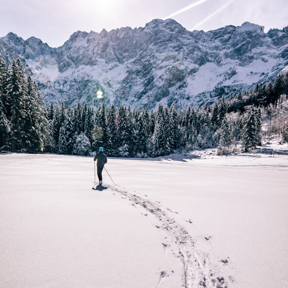
SKI TURING
For all experienced skiers, we have prepared some suggestions for a winter full of ski touring pleasures.
For those who are just getting into ski touring, Park Jezersko has prepared excellent ski touring programs. The tour is always adapted to your wishes and abilities. More information and reservations for ski touring tours: PARK JEZERSKO
Come and enjoy!
Ski turing destinations in Jezersko
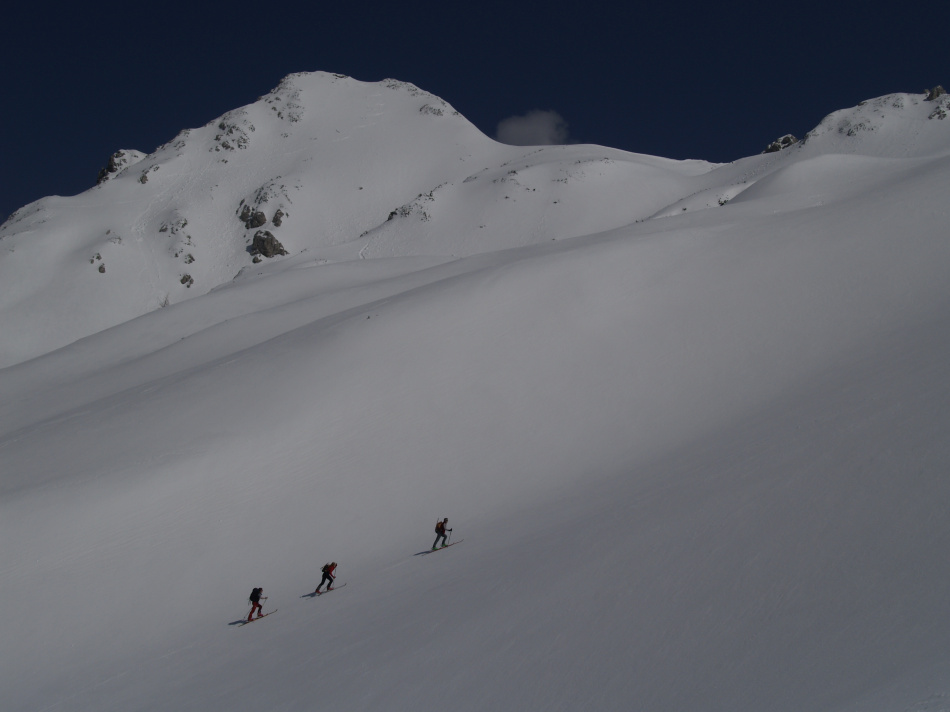
| Ledinski vrh (2106 m)
Classic, spring-time ski touring. Each winter is different, but the best conditions are usually encountered between February and April.
More
|
Ledine, Jezersko sedlo, Ledinski vrh(2106 m), Savinjsko sedlo (2001 m) in Okrešelj 1000 m, 2–3 h (for the ascent) Ledine (the area around Kranjska koča), is the only place above Jezersko that allows for The itinerary starts in the valley of Ravenska kočna, where you can park your car and follow the cross-country skiing trail to the ropeway bottom station. There are several ways to access the vast slopes of Ledine. The easiest and most popular option is to follow the line of Lovska pot (Hunters’ Trail) to Kranjska koča. In snowy winters, it’s possible to go from the bowl below the Ledinski Falls directly up a steep gully which brings you to the hut (steep icy step, 5 m). Another, easier option is to follow the line of the marked trail through Žrelo (200 m of steep terrain requiring some climbing). Crampons and an ice axe are mandatory for all three options. You can put your skis back on at the hut and skin up the wide slopes to Jezersko sedlo (2001 m) or Ledinski vrh (2106 m). From Jezersko sedlo, you can ski into the valley of Belska kočna or continue across Savinjsko sedlo to Okrešelj. The best way to descend to Ravenska kočna is to follow the line Lovska pot. Elevation difference: 1000 m
Ascent time: 4 h
Starting point: Parking Turni
Gpx: Trail
Descent
| 
|
|
|
|
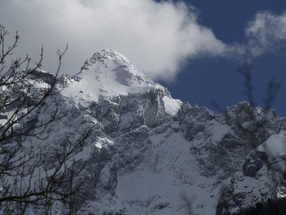
| Grintovec (2558 m)
Grintovec is the highest peak of the Kamnik-Savinja Alps with an imposing north face rising above Jezersko. Its south-facing slopes, however, are home to a magnificent ski touring itinerary, perfect for experienced mountaineers.
More
|
From Jezersko, we’ll drive to the valley of Kokra and the starting point of this itinerary: the Suhadolnik farm (900 m). Two trails lead over the first rocky barrier (Taška) and the right-hand option, which is less steep, is the best with skis strapped onto your backpack. With enough snow, it might even be possible to ski down here. Continue towards the hut of Cojzova koča na Kokrškem sedlu. The slopes are vast, so make sure not to miss the ramp leading to the upper part of the tour, the so-called Grintovčeva streha (Roof of Grintovec). In absolutely perfect conditions, it’s possible to skin all the way up to the summit, but the climb to the top is much safer with cram- pons and an ice axe. The slope is vast and complex, so it’s best to keep to the skin track while skiing. A grand tour. The descent follows the ascent route.
Elevation difference: 1500 m
Ascent time: 6 h
Starting point: Parking Suhadolnik
Gpx: Trail
Descent
|
|
|
|
|
| Goli vrh (1788 m)
The tour to Goli vrh, which has the best views in Jezersko, is often done in the depth of winter, usually right after heavy snowfall.
More
|
The tour to Goli vrh, which has the best views in Jezersko, is often done in the depth of winter, usually right after heavy snowfall. It’s covered with forest, which substantially reduces avalanche danger. Start in Ravenska kočna, preferably by following the cross- country skiing trails. Most of the time, there are two skin tracks to Jenkova planina. The first one, which is steeper, starts to the left of Gorniški Center Davo Karničar and is used for the ascent only. The second one starts at the large summer parking space in Raven- ska kočna, and this is the line that is usually skied. After about an hour, both options join at Jenkova planina. Head up a narrow and steep clearing running along the border before crossing over to the Austrian side, where the terrain is more open. The best skiing can be found at the grassy slopes near the top and in the sparse beech forest above Jenkova planina. The descent follows the ascent route.
Elevation difference: 800 m
Ascent time: 3 h
Starting point: Parking Turni
Gpx:Trail
Descent
|
|
|
|
|
.jpg)
| Pečovnik in Plešivec (1801 m)
The valley of Komatevra with the peaks of Pečovnik and Plešivec was discovered by local ski tourers while looking for an alternative route for our traditional skimo race.
More
|
The snowy roads, tracks, and open meadows with views of the Kamnik-Savinja Alps are perfect if you appreciate unspoiled nature and peace. All ascents and to a lac of snow. The snowy roads, tracks, and open meadows with views of the Kamnik-Savinja Alps are perfect if you appreciate unspoiled nature and peace. All ascents and descents are technically straightforward and suitable for beginners.
The tour usually starts at the Robnik farm (the road to the farm is plowed regularly and there’s a parking space at the trailhead). From Plešivec, you can keep going to Dolga njiva and Tolsta Košuta (2057 m), but take care as its south-facing grassy slopes can be very avalanche prone.
The descent follows the ascent route.
Elevation difference: 800 m
Ascent time: 3 h
|
|
| Pristovški Storžič (1759 m)
Pristovški Storžič is another beautiful viewpoint on the Austrian-Slovenian border. The summit and the path are entirely on the Austrian side – the hiking trail is marked with yellow direction signs.
More
|
The summit ridge is elongated and gentle, but in places very exposed; the same applies to the summit, where a majestic metal cross stands with an inscription from a completely different time. You are rewarded with a beautiful view over Carinthia and the region of Kranj, from Grintovci over the Karavanke to the Julian Alps. Starting point: Turn-off for the Jenkova Kasarna MuseumIn good winter conditions, you can set off on skis from Zgornje Jezersko. At the main road, at the beginning of the ascent to the Jezerski Vrh border crossing, you will find a marked turnoff onto an old path that leads to Jezerski Vrh. The ascent follows a marked trail to the border crossing at Jezerski Vrh. From here, continue along the road between the border crossing buildings, follow the yellow directional signs, and turn right. The ascent continues on a forest road, which you follow to a second turnoff on the left. Continue along the forest road until you reach a meadow on the left side. The meadow is crossed by a shepherd's path, which you follow up to the end of the grassy slope.
From here onwards, full winter gear (crampons, ice axe, and helmet) is required to access the summit of Pristovški Storžič!
The descent follows the ascent route.
Elevation difference: 750 m
Ascent time: 2 h
Descent
|
|
Starting point: Jezerski vrhThe ascent begins on the road between the border-crossing buildings. Then, follow the yellow directional signs and turn right. The ascent continues along a forest road, which you follow to the second turnoff on the left. Proceed along the forest road until you reach a meadow on the left side. The meadow is crossed by a hiking trail, which you follow up to the end of the grassy slope.
From here onwards, full winter gear (crampons, ice axe, and helmet) is required to access the summit of Pristovški Storžič!
The descent follows the ascent route.
Elevation difference: 450 m
Ascent time: 1h 30 min
Starting point: Jezerski vrh
Gpx: Trail
Descent
|
|
|
|
| Štularjeva mountain pasture (1270 m)
The tour begins in the peaceful and pristine Ravenska Kočna valley and leads through snow-covered forests to the idyllic Štularjeva mountain pasture. The route is easy and suitable for beginners as well as experienced backcountry skiers seeking a relaxing and safe tour.
More
|
Start the tour at the beginning of Ravenska Kočna – most likely on the cross-country skiing tracks near Park Jezersko. Continue along the thematic path all the way to the large parking lot in the Ravenska Kočna valley, then follow the road that will take you to the lower station of the cargo cable car to Češka koča. Here, turn right, and in front of you, there are still about two kilometers of ascent along a snow-covered road. At Štularjeva mountain pasture, take your time to admire the views of the valley and the Kamnik–Savinja Alps. Due to the forest cover, the avalanche risk is low. The descent follows the ascent route. Elevation difference: 350 m
Ascent time: 2 h
Starting point: Parking pod Turni
Gpx: Pot
Descent
|
|
|
|