Municipality Jezersko
The Municipality of Jezersko comprises the surface area of 6881 hectares. Surrounding municipalities are Tržič, Preddvor, Kamnik, Solčava, and in the north the Republic of Austria. The Jezersko municipality has two settlements:
Spodnje Jezersko (694-1080 m) starts at the provincial stones, the historical border between Carniola and Carinthia, at the hamlet of Zgornje Fužine.
First part of the settlement is Podlog (Kanonir) situated at the confluence of rivers Kokra and Reka, which flows from the area under Storžič and Stegovnik mountains, and it ends at the hamlet Dol. Second part is called Spodnji kraj (Bajte), situated at the confluence of rivers Jezernica and Kokra. Part of Spodnje Jezersko are also individual farms located along the river Kokra up the Komatevra valley all the way to below Virnikov Grintovec, Stegovnik and Ruša mountains.
Other parts of Spodnje Jezersko are named after remote farms, some of them having up to 360 hectares of land.
Zgornje Jezersko (903-2558 m) is a scattered settlement; its northern part called Ravne was populated first in the valley. Zgornje Jezersko of today has many parts: a bigger central hamlet around the primary school, and smaller ones such as Grabnar, Kvance, Žabji trg, Stara pošta, Sibirija, Anclovo and Raven with farms and houses around the church of St. Andrew.
Statistics from the year 2009 show that 665 people lived in Jezersko, out of which 337 were women and 328 men. An average age of the population was 41,8, that was higher than the national average.
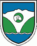
Coat- of- arms
The coat-of-arms of the Jezersko municipality has a shape of a shield and it is bordered by a double line. In the upper part there are sky and mountains, in the middle there is a circle with a sheep head of a special Jezersko-Solčava breed in it. I the lower part there is a blue lake. Green coloured hills in the middle represent the valley and forests, the white part in the middle symbolizes the waterfall.
Meaning of the colours:
Blue: mostly wisdom, depth, prudence and knowledge
Green: purity
White: independence, future, freshness, space
Symbols:
Sheep - a typical animal in the area is Jezersko-Solčava breed.
Mountains - a silhouette of the mountains Kočna and Grintovec as seen from the village.
Lake - the origin and the name are connected to the former glac ial lake that drained away. Today´s lake Planšarsko jezero was created in memory of that lake.
Hills – valleys – forests - closed Jezersko valley surrounded by hills, valleys and forests.
Waterfall - Čedca waterfall used to be the highest in Slovenia
| 
|